 Martinez Tribune The website of the Martinez Tribune.
BY JUDIE & JOSEPH PALMER
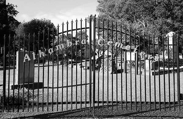
Alhambra Pioneer Cemetery’s eight acres reside on Carquinez Scenic Drive with its Potter’s Field (three acres) located west of the main entrance at the bottom of the hill. We’re often asked when working at the site, “Is this a military cemetery ?” “Are they veterans ?” or “Who is buried here ?” Well the answer to the first is “No” but visitors to the site’s assumptions would be forgiven since 99% of the markers are uniform in size and shape. Although some of its residents are veterans, how many and who are harder questions to answer. After we tell them it’s a Potter’s Field they inevitably ask, “What is that ?”
The term comes from a biblical reference to Akeldama, in the valley of Hinnom that was a vast source of potter’s clay. After the clay was removed, numerous pits, holes, and trenches were left behind leaving it unsuitable for farming. The site was then repurposed to address the need for interring those deemed unworthy of burial in the Orthodox cemetery. As a result, any cemetery or portion thereof devoted to the burial of the indigent, unclaimed, unknown, or criminals is referenced as a “Potter’s Field.” Unfortunately, in the case of Alhambra’s, most people of color, immigrants, and other marginalized groups were relegated to burial here.
The history of Alhambra Cemetery (considered to be the oldest in the County and one of the oldest in the state) is both convoluted and partially unknown along with its Potter’s Field. For that reason, a primer on the entire cemetery is needed. It most likely started between 1830 – 1840 as “Cemeterio del Hambre (Cemetery of Hunger)” on property contained within the original “Rancho El Pinole” land grant owned by Don Ignacio Martinez. Although none of his family are buried there, its idyllic location with vista views of the Carquinez Straight quickly became the chosen final resting place for many locals and dignitaries.
The original survey for the creation of Martinez was conducted in 1849 starting with the cemetery. Blocks ½, 1, 2, 3, 4 border the road, while oversized Blocks 200, 201, 202, 203 face Benicia completing its footprint. Later in 1854, its seizure for payment of unreasonably high back taxes (a tactic widely used to grab Mexican landowners’ property) allows Beverly Holliday and John Livingston to buy it through a sheriff’s auction. To make a quick profit, they immediately sold the property in smaller parcels. This resulted in Dr. Strentzel (John Muir’s Father-in-Law) becoming the largest individual owner when he purchased Blocks 202 & 203 at an unknown date.
On February 6, 1869, the Alhambra Cemetery Association (ACA) forms with the goal of repurchasing the parcels and place them again under one entity. Perhaps the ACA is responsible for the cemetery’s moniker change, although Holliday and Livingston are credited for its establishment. When the ACA purchased Block 201 and a couple of other Lots from Simon Blum on March 11, 1875, they became the cemetery’s largest property owner. Their last purchase was the Southern portion of Block 202 from Dr. Strentzel on August 8, 1887.

With Contra Costa County’s purchase of Lots 3-6 of Block 2 from Simon Blum, Isabella O’Niel, B. Fernandez, and John & Annie Tormey on March 19, 1892, Potter’s Field was officially created. However, interments mostly certainly occurred there prior to the County’s acquisition and whether they would have fit the definition of a traditional “potter” we will never know. Currently all its residents have been lumped together and made anonymous when the County’s cemetery burial record was lost with only a partial list of names having survived.
We previously stated, “The history of Alhambra Cemetery… is both convoluted and partially unknown…” which becomes obvious when discussing Dr. Strentzel’s ownership of Martinez’s Original 1849 Survey Block 202. Again, according to the specific description of the property from county records, he sold the Southern portion of Block 202 to the Alhambra Cemetery Association (ACA) on August 8, 1887.
However, after his death on Halloween 1890 and the subsequent settling of his estate, his wife Louisiana and daughter Louie are given joint ownership of “the south half of Block 202 less cemetery lot of F. Galindo,” and Block 203 on September 17, 1892. This in complete contradiction of the earlier sale to the ACA and it should have read “the north half of Block 202.”
The mistake is further repeated when Louie indentures the land to her daughter Helen Muir-Funk which reads, “and the south half of Block 202, less cemetery lot of F. Galindo,” on July 11, 1905. Further confusing the issue, Helen and her husband Buel Funk sold to the County, “blocks numbered 202 and 203” with no mention of F. Galindo’s lot or the ACA’s portion on August 30, 1919. When the County Assessor’s map of the cemetery is updated, no indication is made of the ACA’s partial ownership of Block 202.”
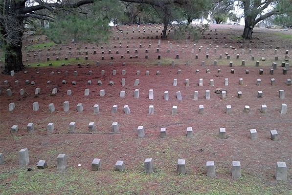
When visiting the area, you will notice that there is a mixture of cement markers, rusted memorial tin stakes, and various gravestones sprinkled throughout (including those of several notable dignitaries like Captain Joseph Walker, his family and Don Salvio Pacheco). As a result, it’s difficult to determine the boundaries of Potter’s Field. Perhaps the County’s (and probably also the Strentzel’s) hiring of ACA employees to bury their dead, might explain why the ownership of the property was never challenged and its burial use muddled.
Speaking of the memorials in Potter’s Field, we have yet another great mystery. Since Potter’s were buried for very little money, their grave markers were simple and inexpensive like wooden crosses, stakes, or sticks bound together with a name carved, stamped or burned into them. By 1890 or so memorial tin stakes were in vogue as tin’s use itself became widespread (although wood continued to be utilized). Whatever wooden markers there where are long since gone, while most of the memorial tins have unfortunately rusted, fallen apart, or simply disappeared.
At some point, cement marker replacements (stones) were installed by the County to substitute the original grave indicators with either a numbered or blank top. The question is when? As stated before, the list that matched the interred with their corresponding stone has disappeared, leaving them currently anonymous.
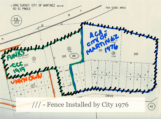
By 1976, the last surviving member of the ACA died causing the City of Martinez to step in and claim ownership of its property. This prevented the State of California from seizing the land for unpaid back taxes and selling it to a developer. After receiving the land, city officials installed a chain link fence around what they considered the cemetery’s perimeter. This resulted in the permanent segregation of Blocks ½ and 1 from the rest of the acreage, (at some point after passing through numerous hands, the County eventually acquires the property).
The final twist of our tale comes on May 12, 1992 when the County Board of Supervisors declares their Carquinez Scenic Drive holdings superfluous. This allows them on June 17, 1992 to give the City ownership of Blocks 2, 202, and 203 while giving the East Bay Regional Park District Blocks ½ and 1.
Currently the City of Martinez hosts a couple of cemetery cleanup days a year, with the next one to be held in the fall with date still TBD. Please consider volunteering that day to give proper reverence towards its residents.
Our Column is sponsored and supported by the Martinez Historical Society (MHS) and the Martinez Cemetery Preservation Alliance (MCPA). For more information, please visit the MCPA website MartinezCemetery.org or the MHS website MartinezHistory.org. Do you have a cemetery story or images to share? Please email us at martinezcemetery@gmail.com or call us at (925) 316-6069.


One comment
Pingback: Five Men, Six Days, and 34 Miles Across the Sierra Nevada - Nevada Digital News